Have you ever had the thought, “That would make a great story!” when it comes to your family history… this is exactly that, “Once upon a time moment.”
 To add historical context and a colorful backdrop, the year was 1968. It was one of the most tumultuous single years in history. Soviet armed forces invaded and occupied Czechoslovakia–Prague Spring; North Korea captured the Navy intelligence vessel U.S.S. Pueblo; The Tet Offensive, an all-out effort by the Communists to inflict terminal damage on the South Vietnamese regime; U.S. ground troops killed many Vietnamese civilians in the My Lai massacre in South Vietnam; both Martin Luther King and Robert F. Kennedy were assassinated; Summer Olympic protests recorded black-gloved fists in a salute to the Black Power movement; Richard M. Nixon wins the White House and Apollo 8 carried the first humans to orbit the moon.
It’s difficult to truly appreciate everything that occurred in 1968 even as we watched it play out on TV.
This story begins as a lovely autumn day 50+ years ago, to the month, when my father (U.S. Army – now Retired) arrived with a team of nine military personnel in the Panama Canal Zone. It’s a journey over a short period of time that will lead him and our family from Fort Bliss, Texas to Kwajalein Marshall Islands and then to the SAFEGUARD AntiBallistic Missile System (ABM) in Nekoma, North Dakota.

Panama Canal
But, first some historical context on Panama. It’s country on the isthmus linking Central and South America. The Panama Canal, a 48-mile-long man-made waterway, cuts through its center, linking the Atlantic and Pacific oceans to create an essential shipping route. It’s designated as one of the “Seven Wonders of the Modern World” by the American Society of Civil Engineers.
You’ve likely heard of the Panama Canal, but you may not know how it works. The Canal is a system of locks that allows ships to ascend and descend in steps, like a staircase. The lock system lifts a ship up 85 feet to the main elevation of the Panama Canal and down again. The Gatun Dam moderates the amount of water in Gatun Lake, an artificial lake created solely to reduce the amount of excavation work that was required to build the canal. The Dam’s hydro-electric generating station provides electricity to operate the locks and a wide range of other equipment in the canal zone.
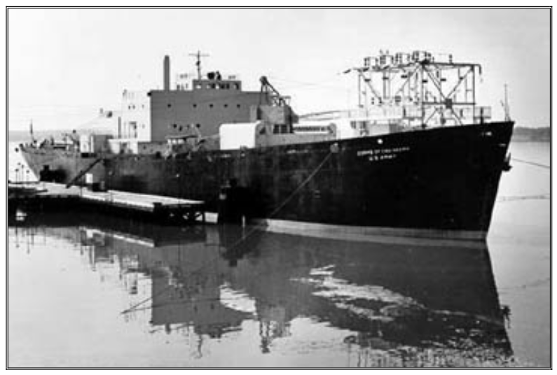
USS Sturgis – Moored at Fort Belvoir, Virginia
Gatun Lake is a critical element of the Panama Canal, acting as a reservoir of water for the operation of the canal locks. Every time a ship transits the canal, each lock chamber requires 26 million gallons (the equivalent size of 35 olympic sized swimming pools) of water to fill it from the lowered to the raised position; the same amount of water must be drained from the chamber to lower it again as the water passes from the lake into the sea.
As the tale went, in early 1968 there was a severe water shortage that jeopardized both the operation of the Panama Canal locks and the production of hydroelectric power for the Canal Zone. The large amounts of water required to operate the locks and the water level on Gatun Lake fell so drastically that operations at Gatun Hydroelectric Station were curtailed. Brown outs and total black-outs from a complete loss of electrical power became the norm.

Andrew J. Weber
Shrouded in military secrecy, was the Andrew J. Weber, a floating power plant equipped with three 1,650-kw diesel generators and two 8,400 kw gas turbine sets, that was designed to provide 20 MW of on-demand electrical capacity. Enough to supply approximately 25,000 homes with electrical power!
The military often prefers strange, far-flung and obscure parts of the world for testing because the Pentagon doesn’t like to advertise them. Such was the case for the power barge which was obscurely in route to KWAJALEIN, Missile Range (KMR) in the Marshall Islands.
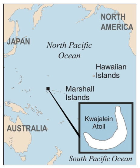
Marshall Islands Location
The increased demand of electrical power for missile-tracking radar at the SECRET Ballistic Missile Defense Test Site was it’s planned duty station, however, the demands of the Vietnam War had significantly increased traffic through the Panama Canal and while transiting the canal en route to Kwajalein Missile Range (KMR), the Secretary of the Army redeployed the “Power Ship” in October 1968 to the Panama Canal Zone at Gatun Lake.
Another historical context for this story is that a few months prior, the USS STURGIS (look, there is a name reference to motorcycles!) a WW II Liberty cargo ship (previously named: Charles H. Cugle) was converted into a 10 MW floating nuclear power barge/ship and was already on location, but could not fully meet the electricity demands. This electrical shortfall added to the decision criteria of the Andrew J. Weber being redeployed to the Panama Canal Zone. The electrical power produced by the Weber and Sturgis replaced the power from the Gatun Hydroelectric Station, and freed up the lake water for canal lock navigation use.

U.S. Army Air Defense Command
The USS Sturgis was the first “ship” to be deployed and the only one in the U.S. Army with a nuclear reactor power plant. The MH-1A plant was a pressurized water reactor and one of a series of reactors in the U.S. Army Nuclear Power Program. Program Video HERE:
In 1968 we lived in El Paso, Texas just off the Fort Bliss military base where my father was stationed. Fort Bliss was home of the U.S. Army Air Defense Command (ARADCOM). The military installation was instrumental in training personnel on Air Defense Artillery missiles, such as Nike Hercules, Nike Zeus, Nike X, and the Sentinel Missile System (renamed to the SAFEGUARD AntiBallistic Missile System (ABM)).
But, I’ve digressed and want to return to Panama.
Arnulfo Arias Madrid was a Panamanian politician, doctor, and writer who served as the President of Panama. He took office on October 1, 1968 and demanded the immediate return of the Canal Zone to Panamanian jurisdiction and announced a change in the leadership of the National Guard. President Arias removed the two most senior officers and selected Colonel Bolivar Urrutia to command the Guard. The Guard staged a coup and removed Arias from the presidency. He served for eleven days! The overthrow of Arias provoked large scale student demonstrations and rioting in many areas. The military seized power, suspended civil liberties, censored the press and deployed combat troops to help the police make hundreds of arrests.

Fairbanks-Morris Model 38D-8-1/8 Diesel Engines
It was during this political strife that my father arrived with a team of nine military personnel. In fact, the day before the team (notable members: Roger Ashpole, R. Cunningham, Dave Mathews) arrived, the Chief of the Panama Police was assassinated. They rucked it over to Balboa, Panama, (Atlantic side of the canal power system) in civilian clothes due to the U.S. being cast as villains in the coup and immediately initialized start-up procedures of the power barge. They spun up the Fairbanks Morris Diesel Engine/Generators and gas turbine sets and operated three shifts–3 guys to shift 24×7.
Speaking of Diesel engines, the power barge had three massive Fairbanks Morris 16 cylinder opposed Diesel engines and two GE LM1500 gas turbines to produce over 20 MW. The Fairbanks-Morse Model 38D-8-1/8 is a two stroke cycle engine with an upper and lower crankshaft and detonates in the middle. They were compressed air started and had a pressure release valve on top of the engine. You’d pull the lower air handle while pulling the top valve until it started firing. The engine was known to have oil everywhere all the time. In fact, drip pans were a “feature” mounted on the side of the huge block that routed leaking oil back into the motor.
The team’s mission was to provide tactical electric power and environmental control capabilities to the canal zone in defense of the economic interests of the U.S. The power barge augmented the USS Sturgis and was able to establish a power generation grid in the canal zone. Eight months later the nine-man team was replaced by a “small” Army company of 125 men.
My father stated that “Life in Panama was not hard, but it was strenuous and the investment of sweat-equity was worth it. It was an interesting time and it was nice working as a liaison with civilian personnel to help restore stability and the operations of the Panama Canal.”
Don’t stop reading! The tropical sun is about to come out and all will be clear.

Kwajalein Marshall Islands
As mentioned above, the Andrew J. Weber power barge was in route to KWAJALEIN, Missile Range (KMR) before being redeployed to the canal zone. Shortly after my fathers Panama Canal assignment we departed Fort Bliss and relocated to the tropical island of Kwajalein in the Marshall Islands. The Marshallese, say: “Yokwe Yuk” versus welcome. Kwajalein Island is one of 97 that make up the Kwajalein Atoll and is situated 2100 miles SE from Honolulu.
The island, a two-mile long flat boomerang strip of land dominated by the runway and dotted with palm trees, tranquil beaches and stunning aqua water with coral reefs are all set under an unrelenting equatorial heat. No one just drops in on the island. For security reasons only staff and their dependents can live on Kwajalein, tourists aren’t allowed. Everyone (military and government contractors) are there in a professional capacity as the island has no private housing. No one actually lived on the island of Meck, that houses a launch facility, which meant a 25-mile helicopter commute for my father every day over water from Kwajalein.

Kwajalein Test Facility
When we lived there and today, no cellphone network exists on the island, residents relied on landline phones which were dotted all around the island, including in the supermarket and on the beaches. There was no Television, but today TV is provided by Central Pacific Network (CPN), a service of the American Forces Radio and Television Service (AFRTS). The Army operates a small fleet of vehicles for official use, but for “islanders” the main mode of transport is bicycles, everyone has one. Underneath the relaxed veneer is a strict security protocol. There were things we couldn’t photograph and doing so would likely get you a permanent pass off-island.

Systems Technology Test Facility constructed on Meck Island on Kwajalein Atoll
The tropical environment of the island makes it sound like a wonderful playground, with work merely an afterthought. Rest assured, the business of the missile range is extremely serious. The radar facility is part of the Defense Major Range and Test Facility Base. They provide range instrumentation, missile launch facilities, mission control center, range safety, meteorological support, and support space operations. The site hosts a suite of unique instrumentation, located on eight islands throughout the Kwajalein Atoll and provides space-, ground- and sea-based sensors of real-time target acquisition and tracking data to a command-and-control center during various Inter-Continental Ballistic Missile (ICBM) tests.

An ICBM target launches from Kwajalein Atoll, Marshall Islands on 03/25/19
For example, earlier this year (2019), the military launched an unarmed intercontinental ballistic missiles (Minuteman III) from Vandenberg Air Force Base in California and tested the reentry vehicle on the 4,200-mile flight over the Pacific Ocean to the Kwajalein Atoll in the Marshall Islands which is now know as the Ronald Reagan Ballistic Missile Defense Test Site.
After a couple of years living the island life in flip-flaps we departed the year-round heat and humidity and relocated to the SAFEGUARD AntiBallistic Missile System (ABM) in North Dakota. We arrived in a particularly intense cold month, the angle of sunlight was stark and non-penetrating, and snow drifts covered everything.
The Complex was authorized by Congress in 1969 and construction began in 1970 for the purpose to defend the offensive Minuteman missiles based at Grand Forks Air Force Base in the event of a nuclear ICBM attack by the Soviet Union or China.

Stanley R. Mickelsen Safeguard Complex (SRMSC)
The Safeguard system was a cluster of military facilities in Cavalier County, N.D. and consisted of several primary components, the Perimeter Acquisition Radar (PAR), the Missile Site Radar (MSR), the Spartan missile launchers, co-located Sprint missile launchers, and Remote Sprint missile launchers (RSL).
As originally proposed by President Johnson in 1967, the system, then known as Sentinel, was supposed to provide protection for major cities against a ballistic missile attack. The “Pyramid” as it was called by locals, was located in Nekoma, N.D. and was the main control of the Safeguard system. It housed the computers and a phased array radar necessary to track and hit back at incoming ICBM warheads. The facilities were a technological marvel at the time. The structure is 80 feet tall and has four-foot-thick concrete walls sloped at a 35-degree angle to protect it against a potential nuclear blast. Each face of the structure had the ability to scan the landscape and skies for targets coming from any direction. The MSR provided launch and control for Spartan, and the shorter-range Sprint anti-ballistic missiles.

Dependent Housing – Nekoma, N.D.
The facility was later re-named the Stanley R. Mickelsen Safeguard Complex (SRMSC). The ABM debate in the Senate and the impact of the SALT II treaty proved to be a turning point—as the facility became active in April 1975, fully operational in October 1975 and was shut down in February 1976.
The Library of Congress has an extraordinary set of images documenting the Stanley R. Mickelsen Safeguard Complex in various states of construction and completion.
At various times from 1973 to 1976, both my father, and I worked at the MSR. We spent a lot of time in the underground power plant and it was rather impressive. There were several Cooper-Bessemer Company, 4-cycle, turbo-charged, dual-fuel (diesel or natural gas), V-12 engines which supplied electricity to the complex when commercial electricity failed or when there were mock attack tests. The engine turned a 2-ton fly wheel connected to a General Electric generator. The complete unit weighed 35 tons and was shipped in via rail to the facility during initial construction.

RSL #2
In addition, we worked at the four Remote Sprint Launch Sites (RSLs). The MSR could command the launch of Sprint missiles located at the RSLs. The Spartan missiles were designed to intercept incoming warheads at high altitude at distances in excess of 400 miles. Sprint missiles are a super quick-reaction missile used to knock out enemy warheads at close range. A Sprint launch is dramatic….its acceleration is immediate, stunning and literally as fast as a bullet (zero to Mach 10 in 5 seconds! Video HERE.).
The history of the SRMSC is fascinating on many levels and I’ve only scratched the surface. If you like deep dives, please check out David Novack’s comprehensive web site HERE.
 Unclassified CIA Sidebar: The Kwajalein Missile Range (KMR) was a test site for ICBM missiles along with the testing validation for SAFEGUARD. And then there is this from an unclassified CIA document (page 40): “In September 1969 in connection with an estimative paper on the Soviet ICBM designated the SS-9. CIA analysis indicated that the new Soviet missile, then nearing deployment, had powerful capabilities, but they were uncertain exactly how powerful. An unanswered question was whether the multiple warheads of the SS-9 were fitted with individual guidance systems to direct them precisely to dispersed US missile silos. The Nixon administration was just then seeking public and Congressional support to develop and deploy an antiballistic missile defense system, the Safeguard ABM. To provide a rationale for the multibillion-dollar ABM system, Laird and the Pentagon seized the Soviet development of the SS-9, claiming that its triple warheads were individually targeted (Multiple Independently Targeted Re-entry Vehicle, or MIRV). This weapon, military analysts declared, would enable the USSR to destroy the bulk of the US Minuteman ICBM force in one strike and demonstrated the Soviets’ intention to develop a first-strike capability. The US ABM system, they argued, was an essential antidote.“ The antidote became the Safeguard Ballistic Missile Defense site (Nekoma, ND) which was later re-named to the the Stanley R. Mickelsen Safeguard Complex (SRMSC).
We departed North Dakota and relocated to Fort Belvoir, Virginia. Fort Belvoir is home to a number of important U.S. military organizations and has nearly twice as many workers as The Pentagon. More on this station duty at a later time.

Safeguard Ballistic Missile Defense site
So, lets connect the dots on this rather long post… we started out in Texas, the home of the U.S. Army Air Defense Command learning about HAWK and NIKE missile systems. Then a power generation assignment in Panama to stabilize and keep the canal operating. That led to an assignment in the Marshall Islands at the Kwajalein Missile Range and then an assignment at the Safeguard Ballistic Missile Defense site in North Dakota. All of it relates to the Ballistic Missile Defense program which represented many years of missile defense training, maintenance and operations.
Why is this important? These were “good ‘ol days” for lots of now older folks -and one that they/we were quite proud of – the learning experience and doing something useful. Most of us look back and smile because there are a few times in anyone’s life when you have a chance to have a special place in the world’s imagination. One of those times was during the Cold War. Our family didn’t choose to have a role in the Cold War, and for the most part we didn’t complain about being moved around and part of the Ballistic Missile Defense program.

SRMSC Power Plant Control Room
Although the thrill of gas turbine sets spinning up in the middle of night while going into “Alert Status Mode” remains strong, the former missile launch sites—once protected by high fences, search lights, and armed guards—are no longer on the front lines of America’s Cold War.
P.S. Today, the Andrew J. Weber was one of 16 vessels scuttled as part of a military target practice program in 2001. The 6,000 ton Andrew Weber was sunk July 19, 2001. It currently lies at a depth of 12,600 feet, about 250 nautical miles south east of Agana, Guam.
P.S.S. Since the late 1970s, the USS Sturgis had been part of the Reserve Fleet, sometimes colloquially called the “Ghost Fleet.” In October 2014, the U.S. Army Corps of Engineers awarded a $34.66 million contract to decommission, dismantle and dispose of the ship in Galveston, Texas where it was towed that winter.
P.S.S.S. Today the topside of the North Dakota SRMSC appears exactly as it did during its existence as an active launch facility. The only part of the original SRMSC installation still in use is the Perimeter Acquisition Radar (PAR) which the U.S. Air Force operates as part of its space track and early warning system. The SRMSC was made available to the highest bidder via an online auction by the GSA. The winning bid of $530,000.00 was accepted in December of 2012 and the sale closed in February of 2013. The new owner is the Spring Creek Hutterite Colony of Forbes, N.D. The Hutterites are a faith group with 45,000 or so members living in several hundred colonies scattered across the North American prairies with a lifestyle similar to the Amish and Mennonites. In addition, the Cavalier County Job Development Authority (JDA) purchased about 40 percent of the land, including the tactical buildings, for $435,000 from a legislative appropriation. That group is invested in the site because of it’s historical significance in the community. They have plans to create a “historical interpretation,” at some point in the future. Related to the RSLs, Mel Sann purchased RSL #3 (now listed on the National Register of Historic Places) site and another was bought by James and Anna Cleveland. The Clevelands renovated the RSL site into a home and it was previously reported they are trying to sell it for $1.25 million. Mr Sann runs tours during the summer at RSL #3 and you can get more information HERE.
Note: This article was developed from discussions, personal notes and photos with my father. In addition, I’ve chronicled a bit of family history from my own experiences, family discussions along with research from various news outlets and internet sites.
Photos courtesy of Time Magazine (’68 Cover); Map data (c) OpenStreetMap (and) contributors, CC-BY-SA; MISSILE DEFENSE AGEN; Stars and Stripes; Library of Congress; Ed Thelen’s Nike Missile Website; U.S. Army; SRMSC Facebook Page
All Rights Reserved (C) Northwest Harley Blog