 The Pacific Northwest…bounded on one side by the pacific ocean and the other side is the mountainous Rocky’s.
It’s perfect for finding a two-lane crowd-free by-way and rolling past acres of lush forest. Those acres can turn into meandering hours of riding the countryside on a motorcycle. In fact, the Pacific Northwest HOG rally will be hosted in the picture-esq Northwest (Portland) in a couple of weeks where we will deliver the aesthetic vision of why we ride!
Welcoming the 1000’s of riders to the adventure will be hot and dry weather. Not only will they encounter the best weather temps, but they will also have to deal with wildfires. Yes, the west could be described as being on fire!

Wildfires In Oregon and Washington State
The fires across the region have forced evacuation, burned down structures and created breathing issues for some. Twenty minutes outside the Portland metro area the air is thick with particulate and smoke permeates the sky for miles across the region. In Washington state over a 1000 people have been evacuated in Chelan county. The Warm Springs fire (Countyline 2 fire) in Oregon has exploded into the largest fire at 36K acres. U.S. 26 is closed at Oregon 126.
According to NatGeo, on average more than 100K wildfires clear 4-5 million acres each year in the U.S. In 2014, some 1.2 million acres burned in Oregon and Washington and sadly this year it’s looking like a repeat.
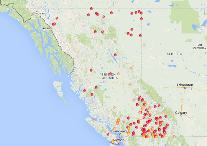
Wildfires In Canada, BC
In scanning the reports I got to thinking about the last time I’ve taken a motorcycle trip during the summer that wasn’t marred with a wildfire. Of course it depends on how many miles I’ve traveled, but in a typical week long ride during the summer I realized that it’s been a fair number of years where I didn’t pass near or through a burning wildfire during a ride. I’ve had multiple trips to Sturgis. Through Yellowstone Park, through Glacier National Park – both with fires on multiple trips. There was U.S. Route 550 or the “million dollar highway” that had a San Jan National Forest fire. There was Beartooth Highway (U.S. Hwy 212) and a lingering wildfire. I’ve taken a couple extended trips up north to British Columbia Canada and the land of lumberjacks was on fire both times. In most all cases we were not close enough to see flames, but dark smoke and particles filled the sky for many miles as we navigated across the country.
In Washington and Oregon there are now 31 major wildfires currently burning. See the map. In Canada BC, there are even more.
In addition to the economic woes that these fires cause it does makes one wonder whether motorcyclists should even consider traveling the west during the height of the summer fire season.
But, life is for living and I’m not talking about the thrill of a car ride snaking through the marquee Going-to-the-Sun-Road in Glacier. It’s about feeling small in a very big world and how that is a great thing on a motorcycle. So, I’ll continue to plan motorcycle trips to ride the west – wildfires and all! Sure some of my photos will be filled with smoke obscuring the mountain views but, just know that I’ll have a big smile underneath that slightly wetted down dew rag covering my face!
Photos courtesy of the Oregonian and NWCC.
 On the first day of fall the saddlebags were loaded and ready for another motorcycle trip. This time the posse pointed our motorcycles south and headed toward some promised fun in the Nevada desert. Street Vibrations was the destination, but our journey through country roads and byway’s was the largest part of the reason that we ride.
 We intersected with Oregon Route 31 south of La Pine and headed east. The highway is a 2-lane, rural road for its entire length. I never tire of the thrill of leaning into a corner and twisting the throttle out — straightening up the bike until you lean back upright and roll into the straightaway — it’s as much fun now as it was back in the early days of dirt bikes.
 We arrived at the Best Western motel in Lakeview with time to watch the last of the sunset and clear the windshield free of our heavy bug collection. Dinner was at a terrific restaurant called the


 From Lolo Pass we headed to


